
产品描述
Product overview
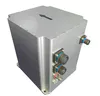
SNC500A fiber integrated navigation system is based on high-precision closed-loop fiber optic gyroscope, accelerometer and high-end GNSS receiving board, through multi-sensor fusion and rotation modulation navigation solution algorithm, to provide high-precision attitude, speed and position information, to meet the requirements of high-precision measurement and control.
1. Product features
▶ With swinging base/moving base alignment function
▶ High precision self-north finding without external movement requirements
▶ GNSS/ odometer /DVL and other multi-information integrated navigation
▶ Long time accuracy retention without external information assistance
▶ Self-detection ability
2. Main application areas
▶ Large UAV benchmark INERTIAL navigation
▶ Marine compass
▶ Positioning orientation
▶ Underwater platform (AUV, ROV, etc.)
▶ Intelligent mining machinery
Working principle
The inertial measurement unit in the INERTIAL navigation system uses three high-precision fiber optic gyroscopes with orthogonal configuration to detect the angular motion of the carrier and output digital signals proportional to the angular velocity of the carrier. Three orthogonal configuration of quartz flexible accelerometer sensitive carrier line acceleration, output proportional to its current signal, the current signal through the conversion circuit into digital signal. The INERTIAL Measurement unit outputs angular velocity and acceleration information.
The inertial measurement unit (IMU) is installed on the rotating mechanism and rotates with the rotating mechanism.
The GNSS board receives the satellite information, solves the navigation and positioning, and sends the navigation result to the navigation computer.
The navigation computer can receive the data of gyroscope, accelerometer and GNSS, calculate the system error compensation and solve the navigation, and send real-time navigation information such as speed, position and attitude through the interface circuit in a specified period.
The inertial navigation system has the function of self-north finding based on compass effect, which can measure the heading value marked by the inertial navigation system. In addition, the horizontal attitude Angle is calculated based on the static base state or reference velocity according to the measured values of the accelerometer and gyroscope.
- 无人机
- 无人及配件
- 雷达
- 硬件
- 导航
- 监测
- 发动机
产能:
未通知
运输时间表:
根据订单的规模
Incoterms:
未通知包装明细:
未通知
更多关于
Shenzhen Nuobashi Trading Co.,Ltd
10-50
员工
未通知
100%
% 出口销售额
Year
成立年份
业务类型
- Industry / Manufacturer
- Distributor / Wholesaler
关键词
- 半导体
- 汽车诊断仪
- 无人机
- 示波器
- 电子元器件
联系方式和位置
-
 Weili ********
-
+86 1********
-
深圳 / | 中国
你可能也感兴趣
-
Xag V50 PRO 农业无人机
Flight platform Basic parameters Dimensions 3018 × 1415 × 583 mm (propellers unfolded) 525 × 1069 × 511 mm (propellers f
-
Original Mk906PRO Advanced Wireless Diagnostic Dev
MK906pro is the latest addition to the MaxiSys product line of advanced wireless diagnostic devices. The device is based
-
Original Al519 Advanced Wireless Diagnostic Device
Original and update Online Autel Link AL519: The Link AL519 OBDII/EOBD Scanner supports all 10 modes of OBDII test for a
-
Original MD806 Advanced Wireless Diagnostic Device
MaxiDiag MD806: The MaxiDiag MD806 is built to take your diagnostic experience to a whole new level. Loaded with oil ser
-
Original Mk808btpro Advanced Wireless Diagnostic D
Car Fitment:Mercedes Benz, Nissan, VW, Ford, bmw, Audi, Toyota and so on Place of Origin:Guangdong, China Type:Code Read
-
Original Ms908spro II Advanced Wireless Diagnostic
MS908S Pro II Feature • Qualcomm 660 Octa-core processor (2.2GHz Quad-core A73 + 1.8 GHz Quad-core A53) • 9.7-inch touch
-
Original XP400PRO Advanced Wireless Diagnostic Dev
Place of Origin:Guangdong, China Type:Engine Analyzer Voltage:12V Power:9W Model Number:XP400 PRO Main Features: 1.XP400
-
Original Ms919 Advanced Wireless Diagnostic Device
Place of Origin:Guangdong, China Type:Code Reader Performance:Exellent Power:20W America Version MS919 Professional Auto
-
Crp123I Crp123e Vehicle Detection Instrument Scann
Automotriz OBD2 Diagnostic Scanner Code Reader Tool X431 CRP123E CRP 123E Free Update 7 Reset Service Creader Profession
-
Original Maxisys Ms906bt Advanced Wireless Diagnos
MS906BT Features: 1: Extraordinarily powerful Samsung Exynos Hexa-core processor 2: 8.0" 1024x768 LED-backlit glossy Mul